About
I am a current M.Sc. Student in Remote Sensing and Geographic Information Systems at the Asian Institute of Technology (AIT), Thailand. I did B.Sc. in Forestry from Institute of Forestry, Tribhuvan University, Nepal. Living in the vicinity of the buffer zone of Chitwan National Park, I have an unparalleled care for nature and its significance in our life. I am an academic researcher in Geography and GIScience with a focus on remote sensing and spatial environmental modelling. My past research examines forest–climate interactions, and hydrological responses through multi-temporal satellite analysis and predictive modelling approaches. I seek to advance methodological innovation and theoretical understanding in Earth system science..
My research focuses on spatio-temporal analysis of environmental change, including forest disturbance, agricultural land degradation, wildfire dynamics, and climate–land–water interactions. I investigate these processes through multi-temporal satellite time-series analysis, spatial modelling, and increasingly, machine learning and deep learning approaches for environmental prediction and pattern detection. Over the years, my work has evolved from conventional GIS-based analysis toward data-driven Earth system modelling. I integrate remote sensing, hydrological frameworks, and climate datasets using advanced analytical techniques such as Random Forest, gradient boosting, and emerging deep learning architectures to improve disturbance detection and environmental forecasting. With more than 4 years of experience in remote sensing and GIScience, I combine field-based ecological understanding with computational geospatial workflows. My expertise lies in developing scalable, reproducible, and AI-enhanced geospatial modelling frameworks that bridge forest ecology, agriculture, hydrology, and climate science. Technically, I work extensively with Google Earth Engine, Python-based geospatial and machine learning ecosystems, and spatial data science tools alongside ArcGIS Pro and QGIS. My recent focus emphasizes predictive environmental modelling, spatial AI, and methodological innovation in Earth observation. My long-term objective is to advance computational GIScience and AI-driven environmental modelling to better understand ecosystem dynamics and support climate resilience and sustainable land management.
Remote Sensing & AI for Environment monitoring
- Birthday: 13 Oct 2000
- Website: sakar771.github.io/po/
- Phone: +977 986 500 5780
- Home: Chitwan, Nepal
- Degree: B.Sc in Forestry
- Email: sakardhakal123@gmail.com
- Work: Available
Seeking for graduate assistantships and/or fundings in RS-GIScience relating to Forestry/Geography/Environment/NRM.
Current Projects
Currently, I am working on research involving use of machine learning approaches for accurate forest change prediction due to deforestation, fire and other disturbances as well as runoff modelling for water security.
Publications
- Aryal, K. R., Mahatara, D., Kumar, R., Khadka, S., Dhakal, S., Bhattarai, S., Adhikari, H., & Jung, D. (2024). Modeling tree stem volume for hill Shorea robusta Gaertn. forests in Karnali. Trees, Forests and People, 18(September), 100675. https://doi.org/10.1016/j.tfp.2024.100675
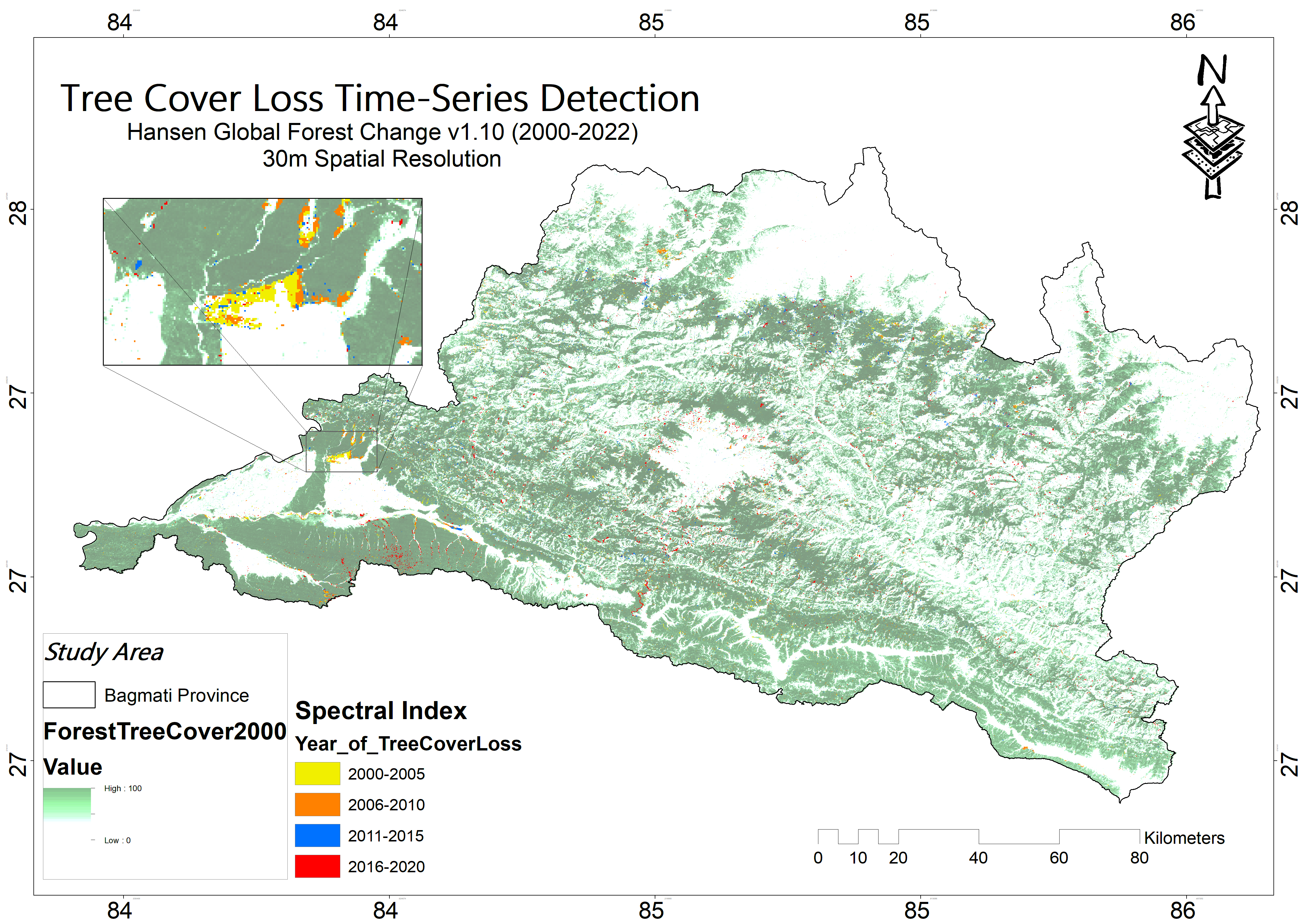
- Dhakal, S., Aryal, K.R., Shrestha, U.B., Adhikari, H. (2026). Improving forest loss mapping in Nepal using LandTrendr time-series and machine learning.Remote Sensing Applications: Society and Environment., 41, 101864. https://doi.org/10.1016/j.rsase.2025.101864.
Skills
I have acquired professional skill sets from engaging in different research projects, workshops, training and courses. In terms of datasets, I have knowledge of OpenStreetMaps, Copernicus ESA, USGS Earth Explorer and Google Earth Pro.
Other than these skills, I am proficient in communication and written tasks. I can work both independently and with a team.
Resume
Sumary
Sakar Dhakal
About 4 years of experience in the GIS field with sheer interest to bring positive changes in environmental policy and system with the impact of maps.
- Bharatpur-7, Chitwan, Nepal.
- sakardhakal123@gmail.com
Education
M.Sc. in Remote Sensing and GIS
2024 - Current
Asian Institute of Technology (AIT), Thailand.
B.Sc. in Forestry
2018 - 2023
Institute of Forestry, Hetauda (Tribhuvan University)
Thesis -
Course Projects:
- Prepared Community Forest Operational Plan of JanaEkata CF, Rautahat.
- Designation of local Volume Table of trees in Hetauda campus forest.
- Spatial data analysis of Crops usage pattern and Chitwan land cover change detection.
- Dalbergia Sissoo detailed research and presentation.
Research Experience
Lead Researcher
-
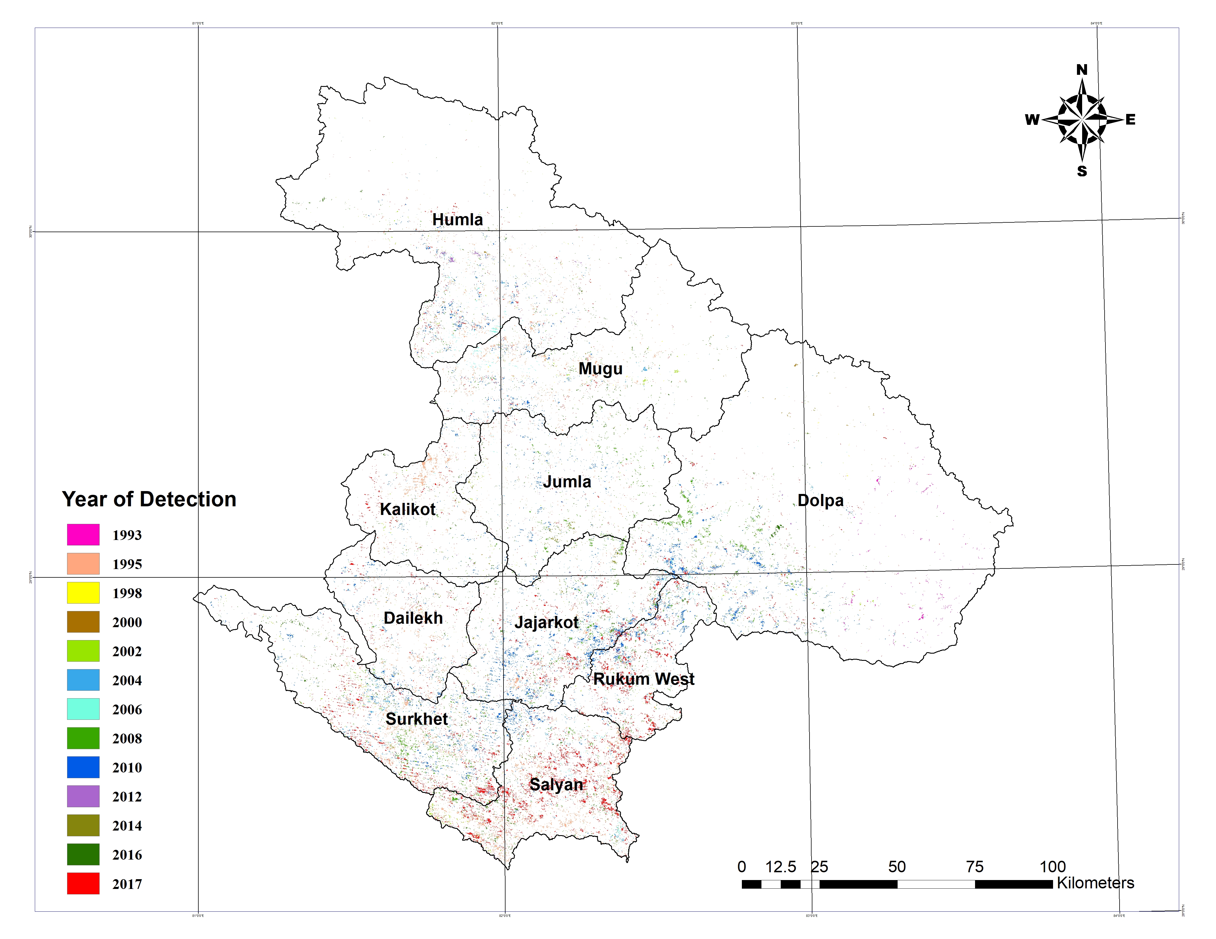
Time-series analysis of forest disturbance and recovery trends of Karnali province using LandTrendr algorithm - Use of temporal segmentation from Google Earth Engine code conduct for abrupt disturbance and gradual regrowth detection: ArcGIS for cartography and GEE, R and MS Excel for data analysis. USGS and Copernicus/ESA datasets used for validations and accuracy assessment.
Research Assistant
-
Assessment of land cover change and its impact on changes in soil erosion risk in Karnali province - Assisted in spatial data extraction through use of GEE, accuracy assessment through unsupervised classification and manuscript preparation. -
Effects of forest management on forest structure and diversity: A case study of Surkhet district, Nepal - Aid in data collection (Bio-physical data with the help of Vortex, Binoculars, GPS and Diameter Tape), GIS cartography and manuscript preparation.
Training and Certifications
- 'Large Scale Applications of Machine Learning using Remote Sensing for Building Agriculture Solutions', 'Assessing the impacts of fires on watershed health', 'Monitoring water quality of inland lakes using remote sensing' and 'SAR for detecting and monitoring floods, sea ice and subsidence from ground water extraction' Advanced Training, ARSET, NASA.- 'Transforming Earth Observation (EO) data into building insfrastructure data sets for disaster risk modelling' and 'Satellite data for air quality environmental justice and equity applications' Intermediate Training, ARSET, NASA.
- 2023 PACE APPLICATIONS WORKSHOP Plankton, Aerosol, Cloud, ocean Ecosystem (PACE) Applications Program, NASA
- 'Cartography', 'Spatial data science: The new frontier in analytics', 'GIS for Climate action' and 'Imagery in action', MOOC by Esri.
- GIS specialization courses: 'Fundamentals of GIS', 'GIS data formats, design and quality', 'Geospatial and environmental analysis' and 'Imagery, automation and applications', Coursera.
- 'R programming', 'Data analysis with R programming' and 'Introduction to TensorFlow for Artificial Intelligence, Machine Learning, and Deep Learning', Coursera.
Professional Experience
Intern
June 2024 - Present
Forest Nepal
- Digitization forests data of Nepal
- Use of Remote sensing and GIS tools for forest cover monitoring and biomass estimation
- Website tools monitoring and feedbacks suggestions.
Research Project Assistant
Nov 2023 - April 2024
Forest Research and Training Centre, Karnali
- Assisted in research design of the project
- Land use land cover map for the study area using CNN from TensorFlow for high accuracy.
- Lead the forest technicians team and community user groups for the field inventory data collection.
GISCORPS Volunteer
Jan 2024 - Present
URISA
- Online contribution by RS datasets mapping.
- Working for human-environment related concerns.
- Contributing for the Humanitarian OpenStreetMap Team projects
Training Facilitator
Basic GIS Training Program
Institute of Forestry, Hetauda
- Organized a one day training program for 50 junior students.
- Class presentation on basic GIS tools, terminologies and cartography.
Event Volunteer
Application of UAV/Drone in Forestry
Division Forest Office, Surkhet
- Managed the technicalities of the event.
- Assisted in aerial data collection of forest species identification.
- Distribution of foods and coordination with the guests.
Research Internee
Jan 2023 - June 2023
FRTC, Birendranagar
- Conducted research design and data collection for the first few months which included acquiring JavaScript hands-on excersice.
- Data analysis - GEE analysis for disturbances and recovery detection, ArcGIS for mapping and use of statistical software like R and Excel for data manipulation for next 2 months.
- Final manuscript preparation and presentation at FRTC during last month.
- Office database management during working hours.
- Active participation in LiDAR and UAVs training relating to forest conservation and management.
- Field work experience on difficult topography for forest species inventory and data collection at Kalika Community Forest(CF).
- Forest species inventory and data collection through surveys of Batuli Pokhari CF and JanaChahana CF.
- Spatial mapping of the study area using ArcGIS.
- Data analysis using R and MS Excel.
Forest Technician
OPERATIONAL PLAN FOR COMMUNITY-BASED FOREST MANAGEMENT (CBFM) PROJECT
Chitwan and Rautahat
Portfolio
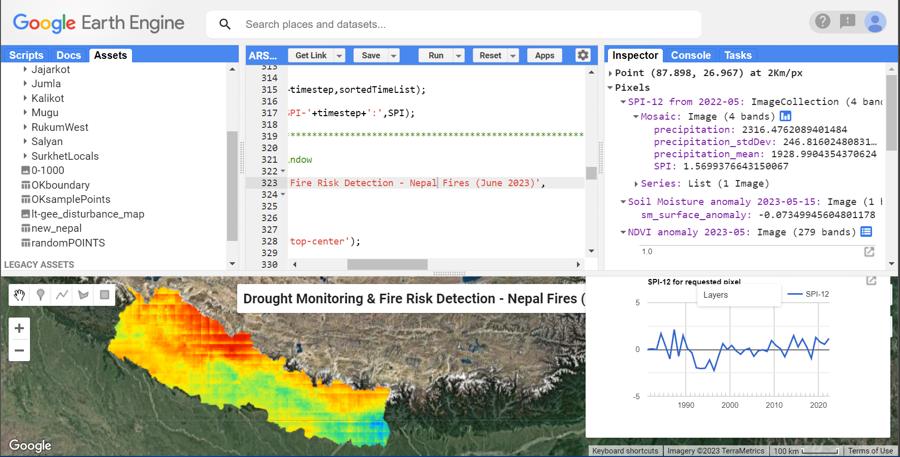
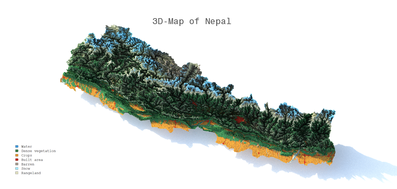
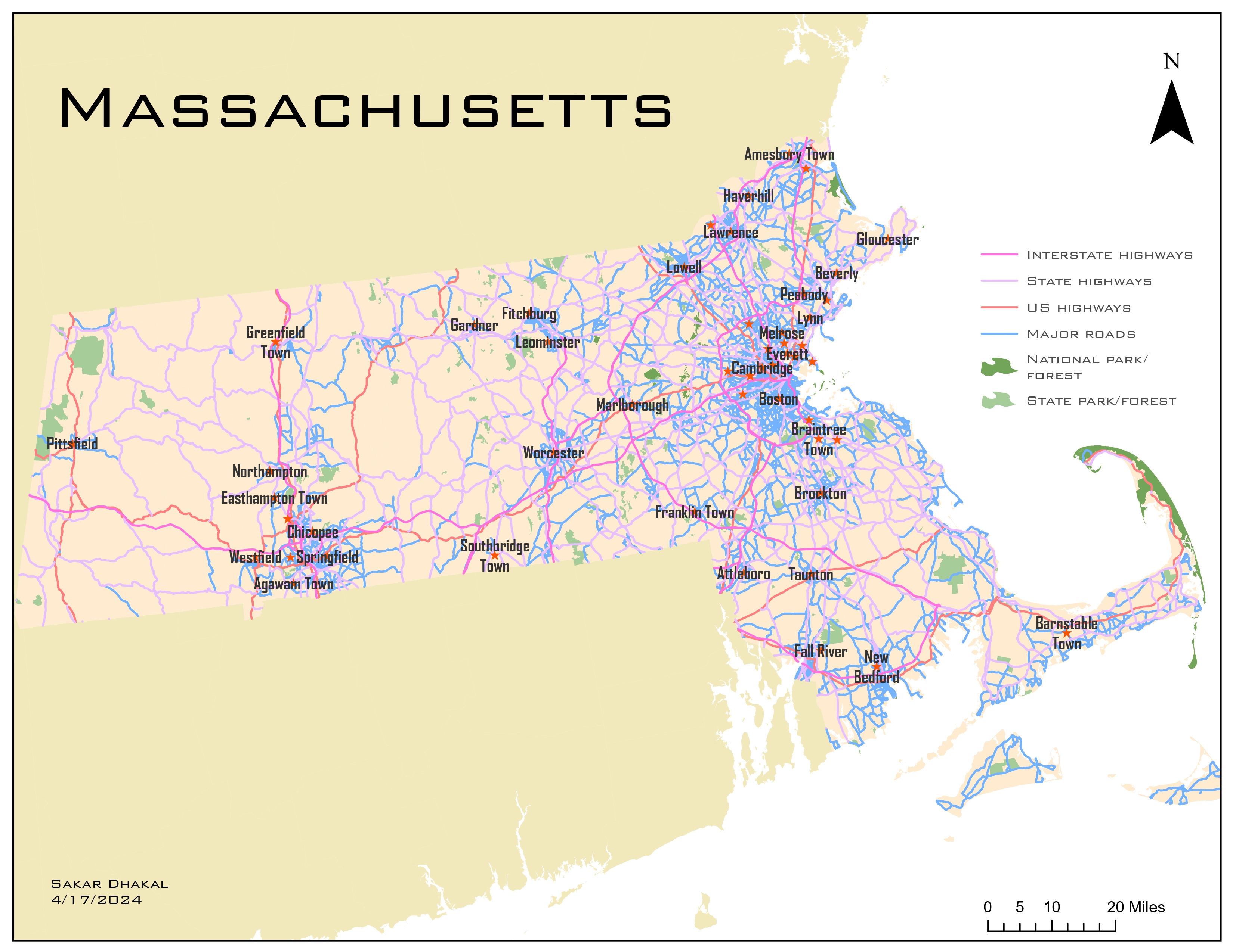
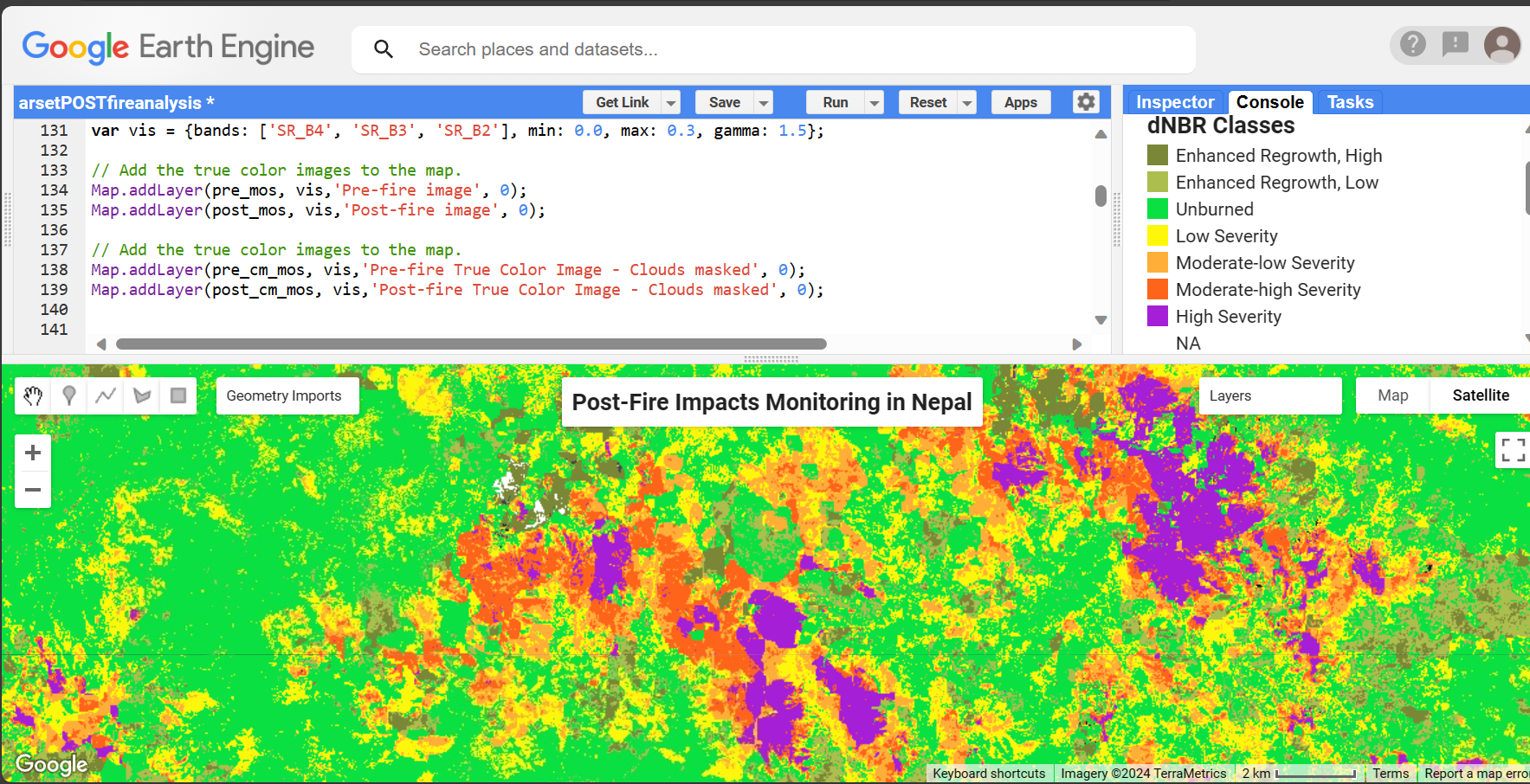
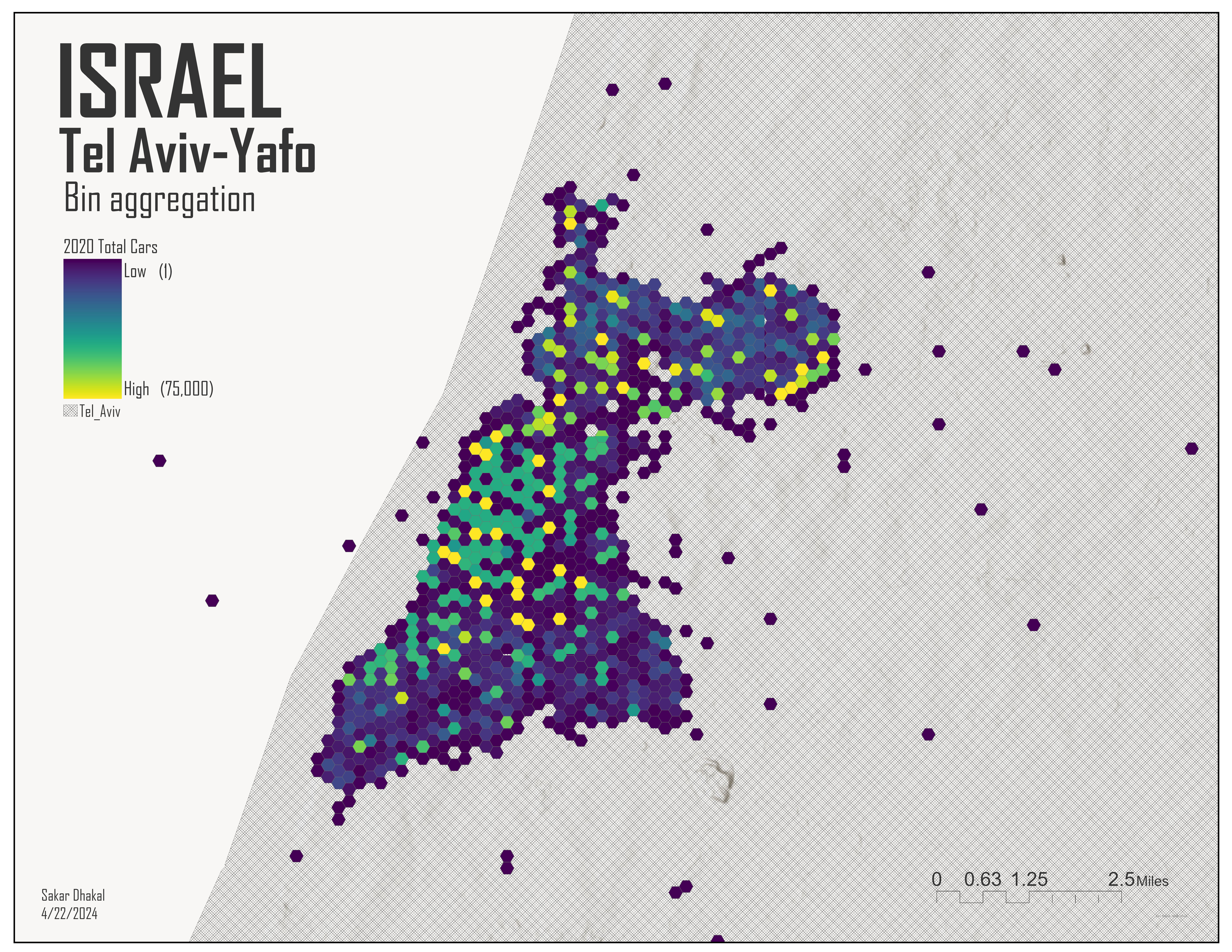
I have an inner love for cartography. From my perspective, I always see GIS as a vast ocean of exploration for tackling environment concerns with innovations. Most of my works are bound to RS data usage, GIS mapping and analysis. However, I have few RS integrated data that I cannot share due to organizational/government legalities.
- All
- Cartography
- Learning
- Work
Contact
Please, feel free to contact me for any additional information. Thank you for the visit.
Location:
Chitwan, Nepal
Email:
sakardhakal123@gmail.com